Category GIS

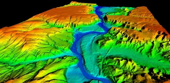
Data Quality & Different Types of Errors in GIS

Digitization errors in GIS

Data quality is a critical aspect of GIS, as it directly impacts the accuracy and reliability of any analysis or decision-making based on spatial data. In GIS, data quality refers to the extent to which spatial data meets the requirements…

Relational Database Management System in GIS

Relationaldatabase management system

A Relational Database Management System (RDBMS) is a software system that is used to manage and organize data in a relational database. In GIS, RDBMSs are used to store, organize, and manage large amounts of spatial and non-spatial data. A…

Terrain Analysis & Its Application & Techniques

Different techniques of terrain analysis

Terrain analysis is the study of the physical characteristics of the landscape, including its topography, geology, and soils. The goal of terrain analysis is to understand the natural processes that shape the landscape and the ways in which humans have…

Relationship Between Remote Sensing, GIS & GPS

jtD9zD96rF

Remote Sensing refers to a technology to gather information about an object or area from a distance, usually from an aircraft or satellite, without physical contact. GIS (Geographic Information System) is a system that captures, stores, analyzes, and manages data…

Different Globally Used Coordinate Systems

Globally used coordinate system

Every spatial object in this earth need to be geo-referenced. It is the process of giving or assigning real world co-ordinate system to the object. Geospatial data should be geographically referenced (called georeferenced or geocoded) in a common co-ordinate system.…

Sources of Data Creation in GIS

Importance of GIS in forestry

GIS data creation is a multi-stage process that includes: Data capture- Primary and secondary data Geo-referencing Digitizing (vector and raster format) Attribute table import and association Metadata preparation Accuracy testing and repair Data conversion to match with other data sets…

Different Types of Digitization Errors in GIS

Digitization errors in GIS

Digitization is a process of converting existing maps to digital form (Vector Format) by tracing the features. Digitization can be done in two ways: Heads-up digitization (on-screen digitization) Heads down digitization (Tablet digitization or manual digitization) Digitizing involves the interpretation…

Importance of GIS: How it Helps in Forestry

Importance of GIS in forestry

GIS is an integrated system of computer hardware, software, and trained personnel linking topographic, demographic, utility, facility, image and other resource data is geographically referenced. NASA The major functions of GIS comprise: Mapping Managing spatially referenced data Design and planning…